Wednesday, July 27, 2016

Gordon Ramsay Pub & Grill, Las Vegas, NV


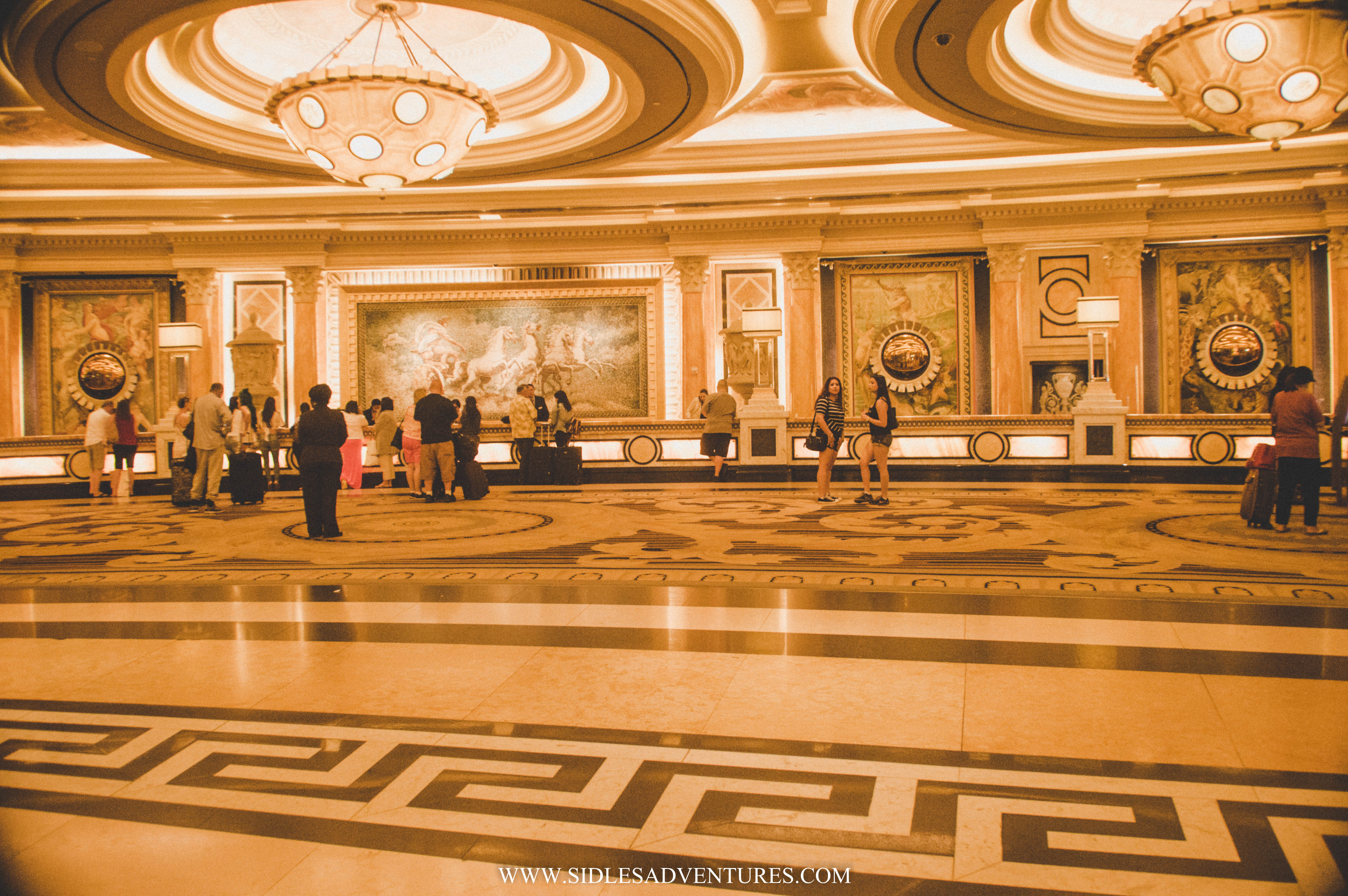
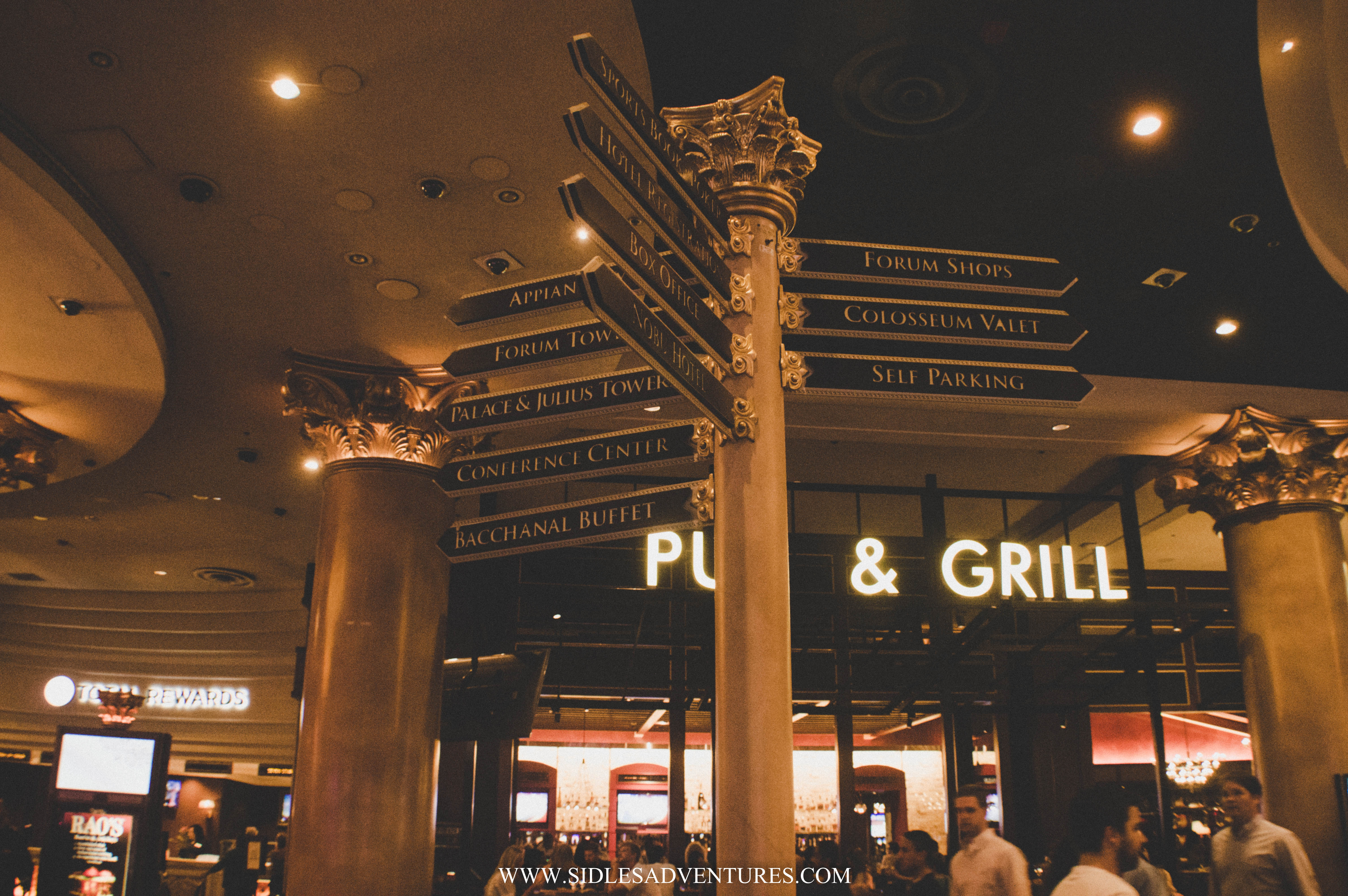
After visiting the Hoover Dam, we decided to go to Las Vegas! It was only a 40 minute drive. I won't bore you with the details, but it was a hot day at the Hoover Dam, and an even hotter day in Vegas (Guess that's what happens when you visit the desert in June) So after gambling a bit, we decided talk walk over to Caesar's Palace and check out what they had there. By the time we made it into Caesar's palace, we were starving. There is no shortage of restaurants in Vegas (all you can eat buffets?) but since we were on a time crunch, buffets didn't fit in.


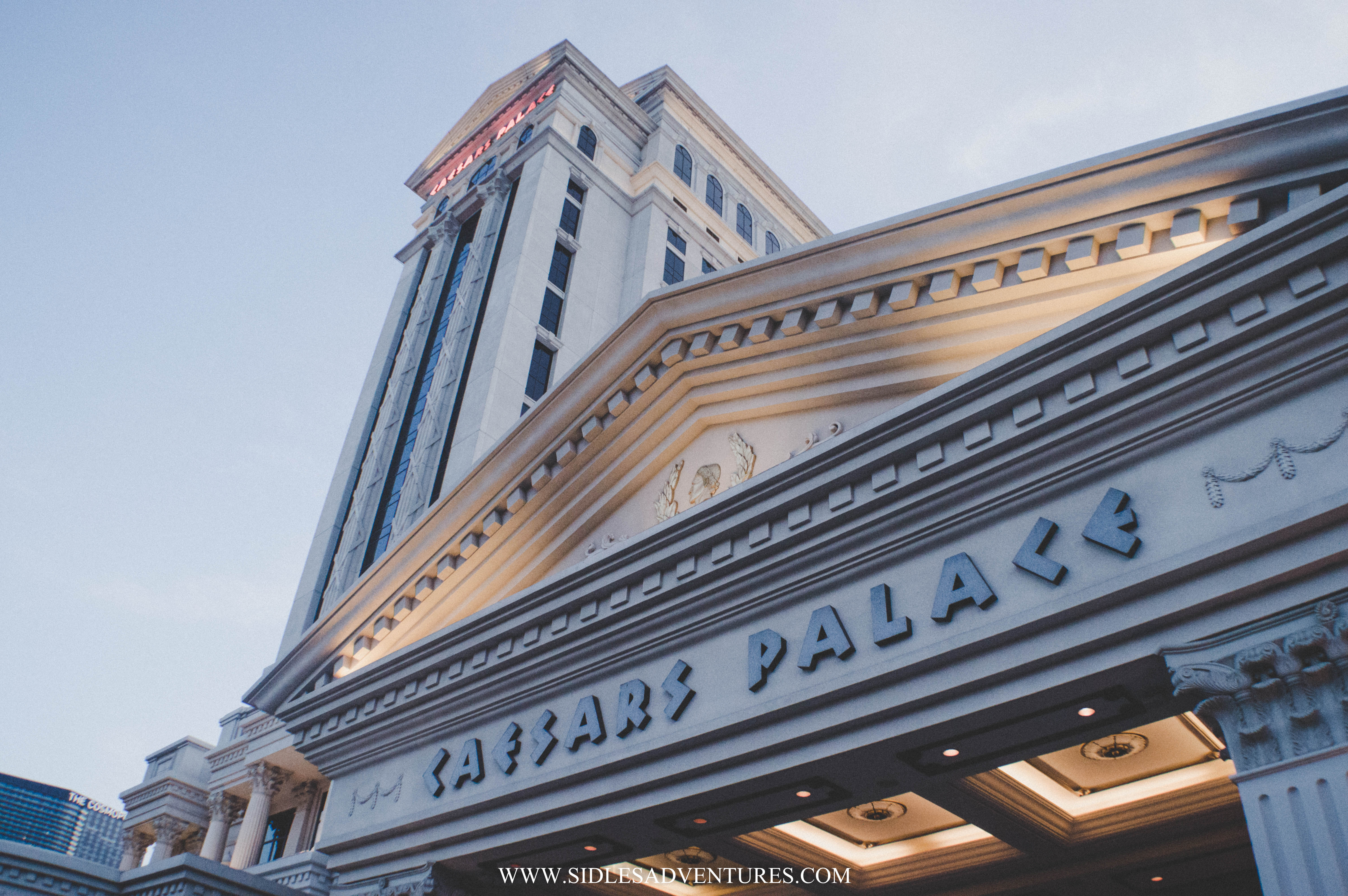
Inside Caesar's palace we stumbled upon Gordon Ramsay's Pub & Grill. You know Gordon Ramsay right? Hell's Kitchen? Or that mean guy with an accent that yells a lot on the food network channel? Haha, yeah him. We ended up eating at his restaurant.


The centerpiece of the restaurant is a striking bar with an array of beer taps and a backdrop reminiscent of iconic British telephone booths. A patio area extends the restaurant towards the casino floor where guests can be part of the action.


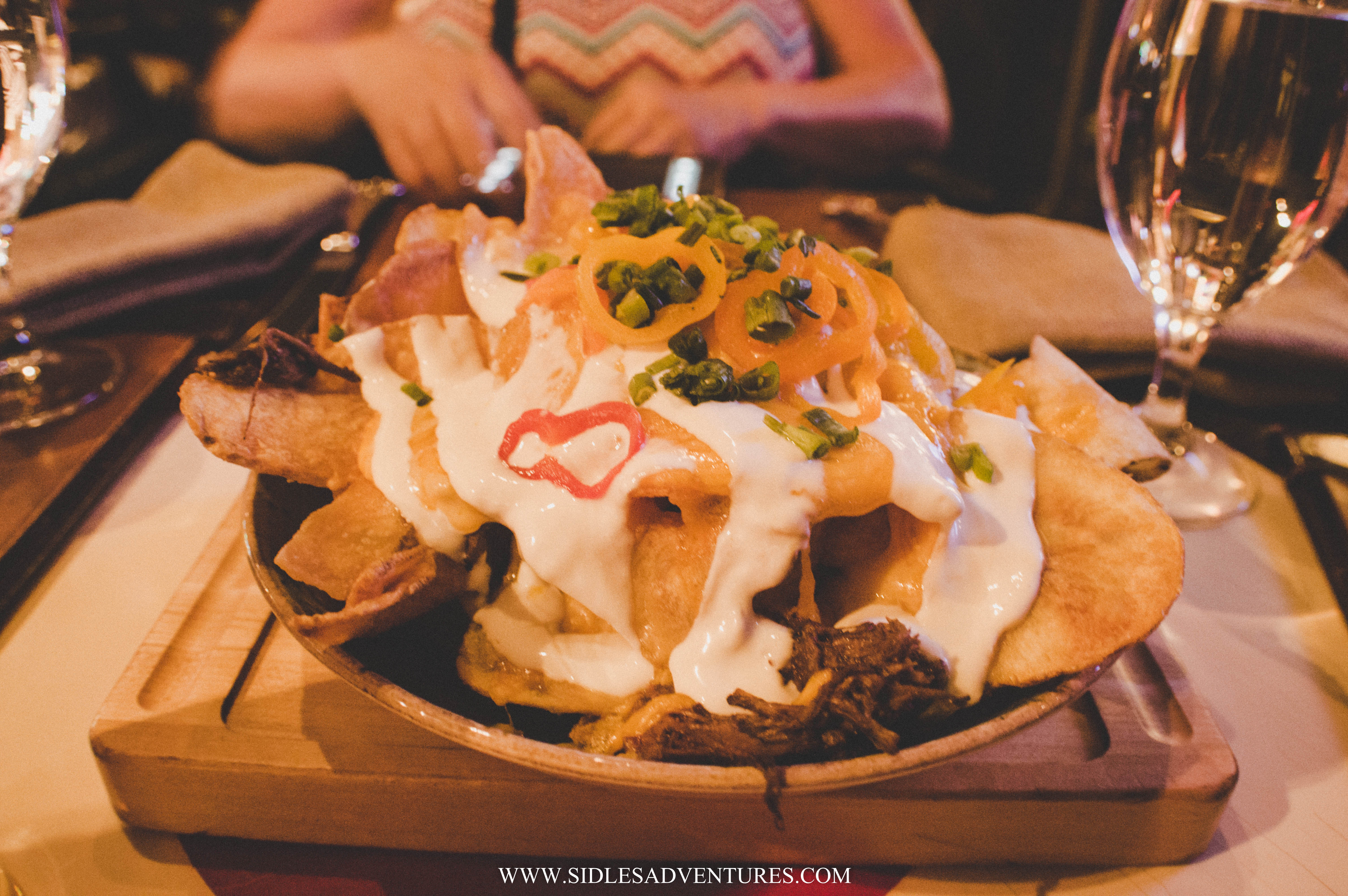
Unfortunately Gordon wasn't there, but I can say his food was pretty amazing. We started off with "Gordon’s Secret Nachos", Corned Beef,Short Rib & English Cheddar Cheese Sauce, Drew was in heaven!


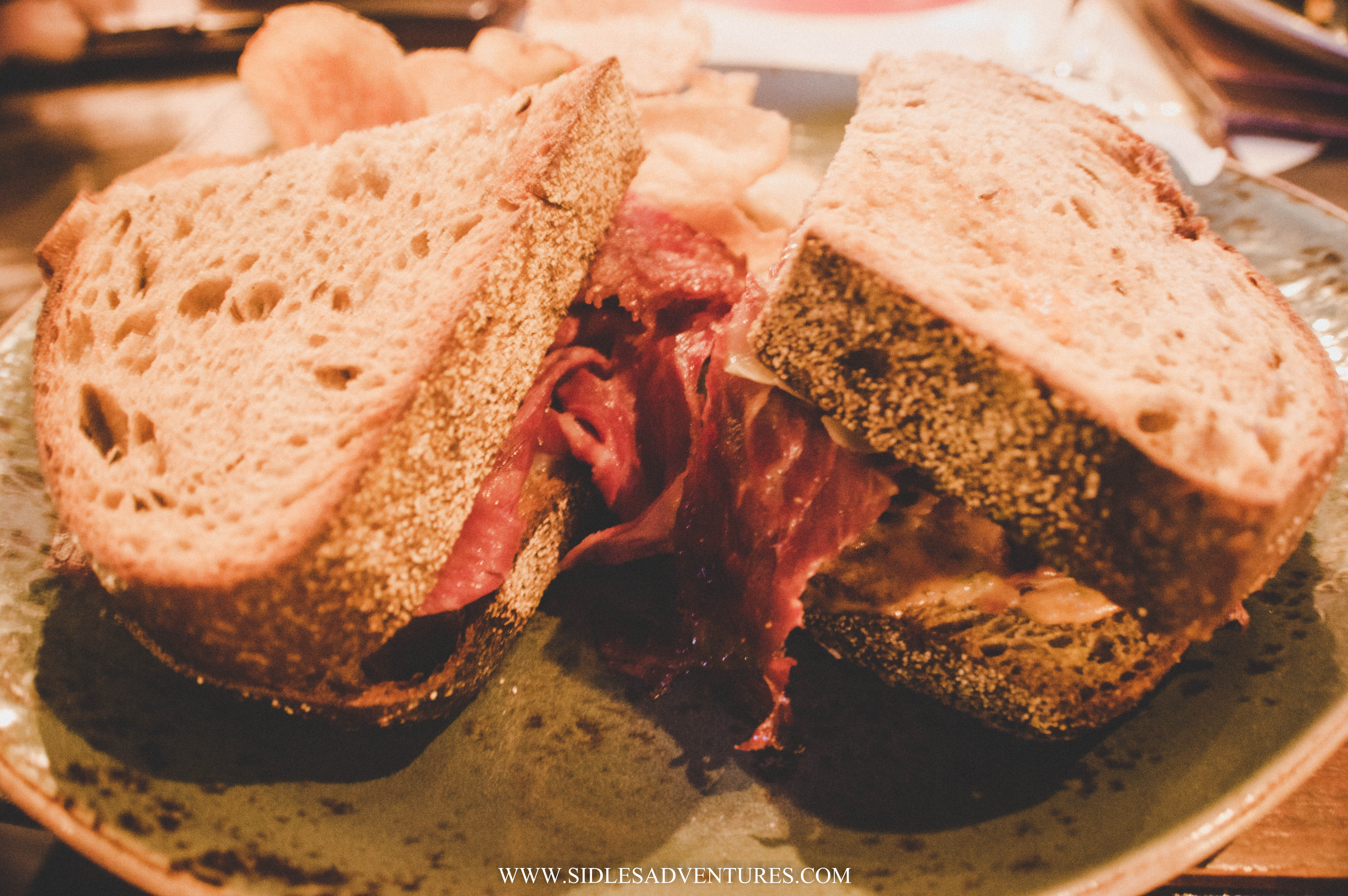
Gwen and I had "The Dublin Corn-beef Brisket", Rustic Caraway Rye w/ Gruyère Cheese, Sauerkraut, Pickled Onion & Dressing.


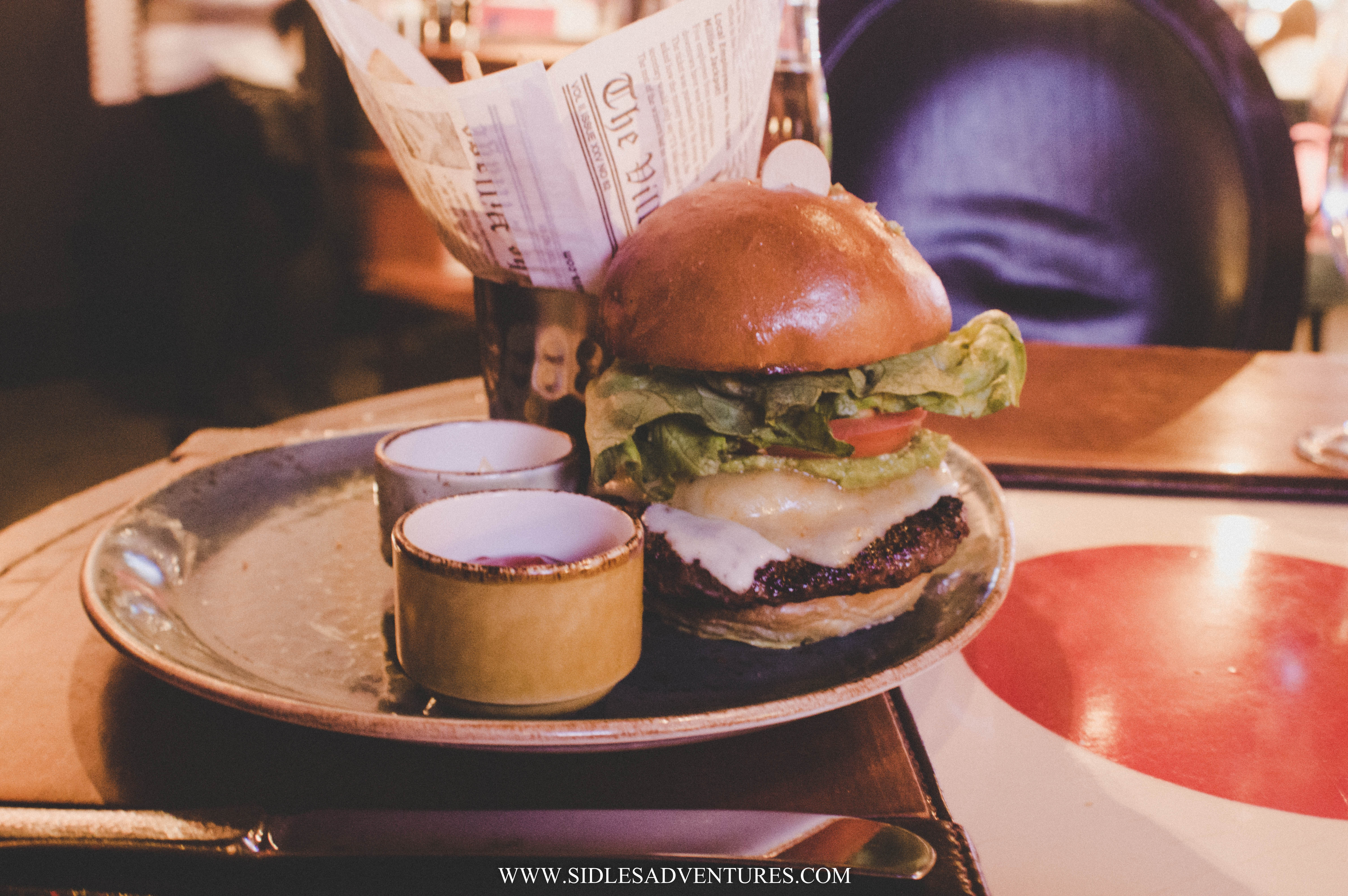
Drew had "Hell's Kitchen Burger", Ghost Pepper Cheese, Pickled Jalapeños, Avocado & Smoked Tomato Aïoli. If you are a burger lover, this is the burger for you! It's named after the show, that itself would make you want to order it.


We were stuffed by the end of the meal. I didn't even finish my sandwich! I can honestly say, if you are ever visiting Las Vegas, make sure to stop off inside Caesar's Palace and grab a bit to eat at Gordon Ramsay's Pub and Grill!

Additional Info:
GPS:  Caesars Palace, 3570 S Las Vegas Blvd, Las Vegas, NV 89109
Cost : $$
Hours: S-Th : 11A-11p | F/S: 11A-12a

Thursday, July 21, 2016

FL to CO : The Road Trip

2,000 miles, 5 days, 6 stops, 8 states

# PCSFL2CO


Map via roadtrippers.com

We are less than a month out from our big move!! Where does the time go? I'm finally nailing down some of the details of how this trip will happen. Originally it was going to be a long trip up the east coast, but after accepting a job offer, and having a start date, I knew that I wouldn't want to lolly gag around places we've already seen, but actually head right for Colorado Springs to get settled!
But of course, maybe it's the planner in me, or the travel blogger, but we are definitely not letting this opportunity go to waste, I'll be documenting our adventure through Instagram! Follow along @SidlesAdventures

Where will we be going?

Stop 1: Tallahassee, FL: Drew is a Florida State Fan. He is a student at FSU, but has never stepped foot on their campus! Blasphemy, I tell you! Since my brother lives in Tallahassee, it was the perfect excuse to stop off and check everything out.

Stop 2: Nashville, TN: I've never been to Nashville, but I hear great things about it! It is country music's home after all! 

Stop 3: St. Louis, MO: I've visited St. Louis about 5 years ago when my best friend was living there. But Drew's never been. Home of Budwiser (although, we'll have Rylie we probably won't go on a tour) It is the gateway to the west! After all we are headed out west!

Stop 4: Kansas City, KS/ Topkea, KS: No plans yet, but neither me or Drew has ever been. Lets hope a Tornado doesn't come and take us to OZ! I think Rylie would have too much fun with the flying monkeys.

Stopping point: Monument Rock, KS

Final Destination: Ft. Carson, CO


Thankfully Drew and I are pros at Roadtrips. I've done my research, but I'd love to hear what is a cannot miss in any of the areas, after, how many times will you drive across the country?!

Monday, July 18, 2016

Devil's Bridge, AZ


Sedona is known for its many hiking trails and outdoor activities. So naturally, when planning our trip, I knew we had to do some type of hike through the red rocks. But the lazy girl in me knew that I wouldn't want to hike for very long, so after some research I found the Devil's Bridge. The Devil’s Bridge is the largest natural sandstone arch (54 feet tall) in the Sedona area. After showing Drew a picture, I knew this was the hike we were going to take.


The Devil's Bridge is one of the most popular hikes in the area, throughout my research I knew that we needed to wake up first thing in the morning and make the hike. Not only because it's Arizona in July, but because it was also a holiday weekend. We had everything planned to wake up at 6am, but when we woke up, it was pouring and it wasn't going to stop until 8am.

Thankfully the rain eventually stopped as we headed into Sedona. There are 3 different ways to get to the Devil's Bridge depending on the type of vehicle you have.


Depending on your vehicle capabilities, you can go on a short hike or a longer trail to the arch. To get to the closest parking area, you need to have a 4WD vehicle, since the last bit of the road is very washed out with a couple of potholes. Since, we only had a little compact rental, it's safe to say we made the right choice to park and hike.


First option is to park in the lot right before the 4WD trail starts and walk alongside the road, or follow the trail (we ended up following the trail then linking up to the road, then walking along the road on the way back) it's about a 3.6 miles RT.


Second option, is to park at the Chuckwagon Trail head, and hike through the connecting trail to the Devil's Bridge. This trail eventually links up near the parking lot and bumpy road, this trail appeared to be a much more scenic route for those looking for a hike. Round trip, you are looking at around 6 miles of hiking if you opt for this path.

In my opinion the first option is the best, you do have to get there as early as possible, when we arrived, there were about 3 other cars in the parking lot. But by the time we left the parking lot was full, and cars were lined up on Dry Creek Road. But if you love to sleep in, take option 2.


We decided to follow the trail instead of walking along the road. It's a bit longer, but the views are absolutely beautiful. I wish Rylie was able to join us on this trip. She would've had so much fun running around.


The trail itself is pretty easy, basically follow the trail until you have to start climbing a rock staircase that leads up the rocks to the arch. At one point, there is a portion of rocks that require you to practically climb up, it looked pretty scary, but it’s not very challenging. In this case, looks can be deceiving!


Once we finally made it to the bridge Drew went running across without a second thought. He scared the crap out of me, from the angle I was standing it looked it he was at the edge! He sure knows how to keep me on my toes! But when I finally made it over I realized that it was much safer than I thought.  Although it looks terrifying to cross the bridge, it is actually about 5 feet across and 45 feet long.


We ended up spending more time at the bridge than we had planned. There was a crowd of people, but everyone was so great about not being on the bridge to let other get their picture.


The hike back down was much quicker than expected. It was about 10:30a once we started making our way down. The sun was high in the sky and the Arizona heat hit us hard. I know one thing, even though our morning didn't start off as planned, I'm glad we started as early as we did!

Friday, July 15, 2016

♥ 5 years

Photo By: Abby Jenkins Photography
I contemplated doing this again this year, but then I remembered why I created Sidles' Adventures. I created this blog as a way to remember not only our travel adventures, but also our daily life adventures. 

Yesterday, July 14, Drew and I celebrated our 5th wedding anniversary. Seriously where has the time gone? It's been an amazing married 5 years. Although, yet again we aren't together to celebrate, lets hope next year we're together, I'm thankful for technology. We were able to google chat, and I got my yearly picture! Haha.


He also sent me a edible arrangement bouquet, with chocolate covered apples with hazelnuts YUM! #besthusbandever

Tuesday, July 12, 2016

6 Favorite Castle Ruins near Grafenwoehr


I love castle ruins. Sometimes I even prefer them to in-tact castles. For those with little ones you'll appreciate the fact that with castle ruins your little ones can run, climb, and touch whatever they want. I do love castle ruins for several reasons, it's free, you usually have to hike (keeps you active), it's pet friendly, and it's open all year round. It's the perfect Sunday activity when you want to do something, but you don't want to venture too far from home.

Here's a list of my top 6 favorite castle ruins (in order of distance) for those of you in the Grafenwoehr area.

+ Waldeck Ruins (20 mins)
Am Schlossberg 40 Kemnath Germany 95478


I might be a little biased with the Waldeck Ruins. Located 3km away from my town Kemanth, every day I see these ruins in the distance and it brings a smile to my face. The castle itself was originally constructed in the 12th Century and was in almost continuous use until its destruction in 1705, at the end of an unsuccessful seven month siege. The castle was besieged several times in its history and passed back and forth in possession between Bavaria, Franconia, and the Swedes. Much of what exists today are reconstructions completed by the local historical society.


Gaisthalweg 2, 92696 Flossenbürg


The 3rd largest castle ruins in the area. It is in a relatively good state of preservation, the unique location and the beautiful view from the living tower make Flossenburg to a worthwhile destination. The "castrum flozzen" was originally one of the main strongholds of Nordgau.
You could also tie this ruin in while visiting the Flossenburg Concetration Camp, it is located less than a mile away.


Waldershof 95679 Germany 
Follow the Brown signs that say Burgruine Weissenstein to the parking lot


The ruins were built on a high rocky cliff and are in danger of collapsing, There is only about a four foot high wall that remains visible. More wall traces were discernible at the wall-like elevations. The Company Steinwaldia Pullenreuth e. V. restored it between 1996 and 2000. With significant time and expense the remaining parts of the building and provided for the preservation of cultural and historical monument. It is a 4km hike/bike ride to the ruins. The pathway is perfect for those looking for a biking adventure.

+ Kurnburg Ruins (50 mins )
Kürnberg, 93491 Stamsried
(This will get you into the town, follow signs it will lead you to the parking lot.)

Burgruine Kürnberg is tucked upon a wooded forest, approximately 1km north-east from Stamsried. The late-Gothic castle ruins Kürnberg is one of the youngest castle ruins in the area, and is a sprawling castle that has a moat, three courtyards, two gatehouses, a main palace, and several partly semicircular towers. There is also a fire pit in the courtyard below the castle. What I enjoyed most with the castle was the lack of people. If you're looking for something to visit where you are able to check it out on your own, this is the place for you.

+ Neideck Ruins  (1 hr )
Am Freibad 7 91346 Wiesenttal


These ruins were a bit of a hike to get to, but I just love the look of the castle and the view from the top was worth it! The large castle complex consists of three deep neck trenches through separate sections. The outer bailey was secured at approximately 100 meters long, 22 meters wide and about 7 meters deep trench. The high defensive wall was built around 1300. From the other buildings are only small traces of foundation available.

Wolfenstein 1, 92318 Neumarkt in der Oberpfalz


I love these ruins for the simple fact that you don't have to hike, you literally park and walk 5 min and you're at the entrance. The ruins of the hilltop castle is located in the central part of the Franconian Alb on the highest point of the Wolf Steinberg. Today, the ruins of Wolfenstein are in good condition. Since the mid-1990s, the association leads Wolfenstein visitors through extensive excavations and renovations in the main castle. Among other things, the ground floor has been exposed. The dense tree and vegetation in the ruins has been removed, so that the walls will get more light and will prevent damage due to moisture. 

Are any of these on your favorite's list? Do you have a favorite that I missed? Let me know. I'd love to hear from you!

Tuzigoot National Monument


If you were following along while we were living in Germany, you know that I absolutely love castle ruins. Thankfully, in Europe there is not shortage of ruins. Since the USA is such a young country and we tend to destroy things rather than preserve them, I was pleasantly surprised to find that there are ruins here in the USA! To be fair, Tuzigoot isn't actually castle ruins, they are ruins, but from a distance they look like castle ruins.


After our visit to Montezuma Castle, while browsing the gift shop, we came across a picture of Tuzigoot. It looked just like a ruin and both Drew and I agreed that if it was nearby we would go and see it. We asked a Ranger where it was located and she told us it was about 30 minutes away in Clarkdale. Turns out the ruins, were about 10 mins away from our hotel (what are the odds?)


Tuzigoot National Monument preserves a 2- to 3-story pueblo ruin on the summit of a limestone and sandstone ridge just east of Clarkdale, Arizona, 120 feet above the Verde River floodplain.
Tuzigoot is the largest and best-preserved of the many Sinagua pueblo ruins in the Verde Valley. The ruins at Tuzigoot incorporate very few doors. Instead they use trapdoor type openings in the roofs, and use ladders to enter each room.


At this site, remains of pithouses can be seen as well as petroglyphs, although the petroglyphs can only be viewed on certain days of the week.


We arrived to Tuzigoot a little after 3:30p, although we have the NPS pass, they stop charging an entrance fee at 3:30 (for those who want a save a few dollars). If you're looking to save some money, check it out at after 3:30. You can walk up to the ruins and see everything in less than 30 minutes. A self-guided, 1/3-mile loop trail leads you around and through an incredible 110 room pueblo. The trail also offers outstanding views of the Verde River and Tavasci Marsh. Follow the road another 1/2 mile round trip, it will take you to a beautiful constructed overlook of Tavasci Marsh. (Much better than the 4km one way to check out ruins!)


Tuzigoot is an elongated complex of stone masonry rooms that were built along the spine of a natural outcrop in the Verde Valley. The central rooms stand higher than the others and they appear to have served public functions. Tuzigoot is Apache for "crooked water", from nearby Pecks Lake, a cutoff meander of the Verde River. Historically, the pueblo was built by the Sinagua people between 1125 and 1400 CE.


This was such an interesting site to see. Unfortunately mother nature wasn't cooperating with us, so we didn't get to stay quite as long as we would've like. But if you're in the area, it is a must see!

Additional Info:
GPS: 25 Tuzigoot Rd, Clarkdale, AZ 86324
Cost: Adults $10 // Children (15 & Under:) Free
National Parks Services Pass: Free
Hours: 8a-4p Daily // Christmas Day: Closed
Pet Friendly
Stroller Friendly

Friday, July 08, 2016

Society6 Shop


I've gotten a few inquiries about my photos and if I sell any of them. It seriously brings the biggest smile to my face, especially since I am NOT a professional. I've decided to start selling some of my favorite photos as prints on Society6!

I'm still tweaking around with the shop, but you can get prints for a decent price. Majority of the costs goes to the manufacture. I make about $2-$5 depending on what size you order, but hey it's a start right? You can order, Art Prints, Framed Art Prints, Canvas Prints, Metal Prints. I'm learning how to turn my prints into clothing! How cool would that be? Feel free to check it out. If you happen to love a specific picture of mine, let me know and I'll make sure to upload it!

Wednesday, July 06, 2016

Montezuma Castle National Monument


Ever heard of Montezuma, the famous Aztec emperor? Well unfortunately these ruins in Arizona are not where he once lived. When European-Americans first observed the ruins in the 1800s, by then long-abandoned, they named them for the famous Aztec emperor Montezuma in the mistaken belief that he had been connected to their construction. The dwelling had been abandoned more than 40 years before Montezuma was even born!


Montezuma Castle National Monument protects a set of well-preserved Ancestral Puebloan cliff dwellings near the town of Camp Verde, Arizona. The dwellings were built and used by the Sinagua people. Montezuma Castle is situated about 90 feet  up a sheer limestone cliff, facing the adjacent Beaver Creek, which drains into the perennial Verde River just north of Camp Verde. This 20 room high-rise apartment, nestled into a towering limestone cliff, tells a story of ingenuity, survival and ultimately, prosperity in an unforgiving desert landscape.


It is one of the best-preserved cliff dwellings in North America, in part because of its ideal placement in a natural alcove that protects it from exposure to the elements. The precariousness of the dwelling's location and its immense scale - almost 4,000 square feet of floor space across five stories - suggest that the Sinagua were daring builders and skilled engineers.


It is an easy monument to visit. On our way to Sedona, we had some time to kill and decided to follow the signs to see the monument. It's just a short distance off Interstate 17, at exit 289. There is a 1⁄3 mile (0.54 km) paved trail starting at the visitor center that follows the base of the cliff containing the ruins.


Unfortunately access to the interior of the ruins has not been allowed since 1951 due to concerns about visitor safety and damage to the dwelling. But it was still very cool to look at, even though it had started to rain. There are about 400,000 tourists visit the site each year! The park is open from 8am to 5pm every day of the year, except for Christmas Day. It is $10 per adult to visit (no charge for children 15 and under) or if you have a National Parks Services Pass, it's free (about $30 a year, you are entitled to 4 adults, or 1 car load) the NPS pass is definitely worth investing in.


It was a quick trip, there are trails that continue on and if it didn't start raining we would've stayed to check things out. If you've got the time, make sure to stop off stretch your legs and enjoy the history!

Additional Information:
GPS: Montezuma Castle Rd, Camp Verde, AZ (I-17 Exit 289 Follow Signs)
Cost: Adults $10 // Children (15 & Under:) Free
National Parks Services Pass: Free
Hours: 8a-5p Daily // Christmas Day: Closed
Pet Friendly
Stroller Friendly